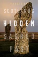
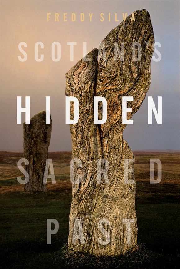
Scotland’s Hidden Sacred Past
Շոտլանդիայի թաքնված սուրբ անցյալը
The Missing Lands Uncovering Earth's Pre-flood Civilization | Անհայտ կորած հողերը Բացահայտելով Երկրի նախաջրհեղեղային քաղաքակրթությունը Շոտլանդիայի թաքնված սուրբ անցյալը Ուրախ ենք ողջունել Ֆրեդի Սիլվային՝ Scotland’s Hidden Sacred Past-ի հեղինակին, որպես հունվար ամսվա մեր գլխավոր հեղինակի: Ֆրեդիի գիրքը ուսումնասիրում է Օրքնի կղզիների առեղծվածային քարե շրջանակները՝ ուսումնասիրելով Շոտլանդիայի նեոլիթյան քաղաքակրթության հայկական և սարդինյան արմատները: Իր հոդվածում Ֆրեդին ուսումնասիրում է այս հնագույն մեգալիթների ստեղծողների առեղծվածը՝ ուշադրություն դարձնելով նրանց հնաստղագիտական կապերին Օրիոնի համաստեղության և աշխարհի այլ հնավայրերի հետ: Շփվեք Freddy-ի կամ AoM ֆորումի հետ այստեղ: here. |
A LITTLE SOUTH AND EAST OF ORKNEY

The remaining yet still impressive stones of Stenness. Around 5300 BC a revolution occurred on Orkney. A group of unnamed seafaring astronomers dared to sail across one of the most hostile waterways in the world to establish the earliest stone circles in the British Isles, along with unusual conical towers and horned passage mounds. Such architecture had no parallel in Britain and had more in common with regions around the Caspian Sea and the Mediterranean. When Scandinavian settlers arrived in Orkney they recorded how the builders of this megalithic culture were physically different from locals, spoke a different language, wore white tunics and behaved like a priestly caste, they formed a society apart. They had long vanished, all that remained were their names: Papae and Peti. The origins of these mysterious people and the monuments they left behind, from Orkney to the Hebrides and into Ireland, aroused my curiosity for years, leading to the publication of my research in Scotland’s Hidden Sacred Past. What follows is a précis. Three stone circles form the axis mundi of Neolithic Orkney. The first, Stenness, is perhaps the most impressive despite only three-and-a-half of its eleven original monoliths remaining. Unlike others of its kind, Stenness looks and feels like a machine or a place of high council rather than an object with which to measure the sky, and it was still remembered as such before the town of Kirkwall took over the role. While looking through the notes of Joseph Banks’ expedition of 1772, I came across a watercolour of a nearby monument that has escaped everyone’s attention. In the foreground, a man sits on a broken stone drawing two megaliths, while a further six stones as tall as Stenness stand behind him. There’s no mistaking the position and orientation of the illustrator, he is on high ground, with Stenness itself positioned in the background with the loch beyond. Between the watercolour and the accompanying survey, one is given the impression of a quadrangular stone monument, and if so, the design seems consistent with similar enclosures such as Crucuno in Carnac, Avebury in England, and Xerez in Portugal, all of which were designed to calculate the extreme rising and settings of the Sun and Moon. | Սթեննեսի մնացած, բայց դեռևս տպավորիչ քարերը: Մոտ 5300 մ.թ.ա. հեղափոխություն տեղի ունեցավ Օրքնիում: Անհայտ ծովագնաց աստղագետների խումբը համարձակվել է նավարկել աշխարհի ամենաթշնամական ջրային ուղիներից մեկը՝ ստեղծելու Բրիտանական կղզիների ամենավաղ քարե շրջանակները՝ անսովոր կոնաձև աշտարակների և եղջյուրավոր անցուղիների հետ միասին: Նման ճարտարապետությունը նմանը չուներ Բրիտանիայում և ավելի շատ ընդհանրություններ ուներ Կասպից և Միջերկրական ծովի շրջակայքի շրջանների հետ: Երբ սկանդինավացի վերաբնակիչները ժամանեցին Օրկնեյ, նրանք արձանագրեցին, թե ինչպես են այս մեգալիթյան մշակույթի կառուցողները ֆիզիկապես տարբերվում տեղացիներից, խոսում էին այլ լեզվով, հագնում էին սպիտակ զգեստներ և վարվում քահանայական կաստայի պես, նրանք առանձին հասարակություն էին կազմում: Նրանք վաղուց անհետացել էին, մնացել էին նրանց անունները՝ Պապա և Պետի։ Այս առեղծվածային մարդկանց ծագումը և նրանց թողած հուշարձանները՝ Օրքնիից մինչև Հեբրիդներ և Իռլանդիա, տարիներ շարունակ հարուցում էին իմ հետաքրքրասիրությունը, ինչը հանգեցրեց իմ հետազոտության հրապարակմանը Scotland’s Hidden Sacred Past-ում: Հետևյալը ճշգրտություն է: Երեք քարե շրջանակներ կազմում են նեոլիթյան Օրքնիի առանցքը: Առաջինը՝ Սթեննեսը, թերևս ամենատպավորիչն է, չնայած նրա տասնմեկ օրիգինալ մոնոլիտներից միայն երեքուկեսն է մնացել: Ի տարբերություն իր տեսակի մյուսների՝ Սթեննեսը կարծես թե մեքենա կամ բարձրագույն խորհրդի վայր է, այլ ոչ թե առարկա, որով չափվում է երկինքը, և այն դեռևս հիշվում էր որպես այդպիսին, նախքան Քիրքուոլ քաղաքը ստանձնել էր դերը: Ջոզեֆ Բենքսի 1772 թվականի արշավախմբի գրառումները նայելիս ես հանդիպեցի մոտակա հուշարձանի ջրաներկին, որը վրիպել էր բոլորի ուշադրությունից: Առաջին պլանում մի մարդ նստած է կոտրված քարի վրա և նկարում է երկու մեգալիթ, մինչդեռ նրա հետևում կանգնած են Սթեննեսի հասակով ևս վեց քարեր: Չի սխալվում նկարազարդողի դիրքն ու կողմնորոշումը, նա գտնվում է բարձր գետնի վրա, իսկ Սթենեսը ետին պլանում դիրքավորվել է լճից այն կողմ: Ջրաներկի և ուղեկցող հետազոտության միջև տրվում է քառանկյուն քարե հուշարձանի տպավորություն, և եթե այո, ապա դիզայնը կարծես համահունչ է նմանատիպ պարիսպներին, ինչպիսիք են Կրուկունոն Կարնակում, Ավեբերին Անգլիայում և Քսերեսը Պորտուգալիայում, որոնք բոլորը նախագծված են: հաշվարկել Արեգակի և Լուսնի ծայրահեղ ծագումն ու կարգավորումները: |

Miller’s watercolour of 1772 of a missing quadrangle of stones. Stenness is in the background
Միլլերի 1772 թվականի ջրաներկը՝ բացակայող քարերի քառանկյունի: Ստենեսը հետին պլանում է

Walden’s survey of the area around Stenness clearly shows a rectangular mound, now missing Along the narrow isthmus to the northwest of Stenness stands a more intact Ring of Brodgar, twenty-seven of its original fifty-six sandstones are still upright (the number required to calibrate the solar and lunar cycles, just as with the Aubrey Holes around Stonehenge). The circle and its 12-foot deep circular ditch were not placed on the high point of the ridge, as expected, but precisely where the 59th degree of latitude runs through the center. | Ուոլդենի ուսումնասիրությունը Սթենեսի շրջակայքի վերաբերյալ հստակ ցույց է տալիս ուղղանկյուն բլուր, որն այժմ բացակայում է Սթեննեսից դեպի հյուսիս-արևմուտք գտնվող նեղ մշուշի երկայնքով կանգնած է ավելի անձեռնմխելի Բրոդգարի օղակը, որի սկզբնական հիսունվեց ավազաքարերից քսանյոթը դեռ ուղղաձիգ են (արևի և լուսնի ցիկլերը չափելու համար պահանջվող թիվը, ճիշտ ինչպես Սթոունհենջի շրջակայքում գտնվող Օբրի անցքերում: ) Շրջանակը և նրա 12 ոտնաչափ խորությամբ շրջանաձև խրամատը դրված էին ոչ թե լեռնաշղթայի բարձր կետի վրա, ինչպես և սպասվում էր, այլ հենց այն վայրում, որտեղ լայնության 59-րդ աստիճանն անցնում է կենտրոնով: |

19th century view of Brodgar Further along the ridge, there’s a third circle, the Ring of Bookan, occupying the high ground from where it is possible to see the other two sites. All that remains of Bookan is a central mound with a collapsed chamber and a circular ditch filled with soil. However, when Frederick Thomas visited the site in 1848 he clearly mentions stones buried around the perimeter, since scavenged for building material; three are still employed nearby as gate posts. Little written information survives on this collection of circles, only folklore. As for age, the earliest C-14 dating of debris from the ditch at Brodgar is 3700 BC, but this only informs us when the site fell into disuse and began to silt. The general archaeological consensus is that Bookan itself was likely built c.4500 BC, fell into disuse by 2900 BC, and was thereafter monumentalized for the interment of human remains. When George Petrie assisted in the excavation of the site in 1861 he too was sceptical of Bookan having been originally used for burial, for a number of valid reasons, and that the orthostatic box he sketched inside the collapsed mound served a different purpose. Since the ancients are known to have built many, if not all, sites according to the rules of sky-ground dualism — whereby the direction or layout of a monument memorializes an important moment in the sky and transfixes it on the ground — I decided to look into the alignment of the three stone circles and see if an archaeo-astronomical date could be established. The axis of Bookan, Brodgar and Stenness follows a general south-easterly trajectory of 129 degrees, giving a potential correspondence to the winter solstice sunrise c.6800 BC. This was surprising because no one should have been building such structures this early and so far north, even though human activity here is radiocarbon-dated to c.6600 BC. But the three sites are not in perfect alignment – Stenness is askew from the others or seen in reverse, Bookan is off-kilter. Any alignment is therefore redundant, and the answer lies elsewhere. It was at this moment that a vivid snapshot of the belt stars of Orion presented itself in my mind. Could this be what the architects had intended? Between Bookan’s strategic vantage point, Petrie’s sketch of its orthostatic box (giving us a useful angle of alignment) and its line of sight pointing to a natural bowl along the horizon formed by the interweaving of natural landscape features, we are offered a site pointing to a hollow from which a celestial object is supposed to rise. The typical markers for sky-ground temple relationships fall disproportionally on two specific times of the year: the winter solstice and the spring equinox. Tracking the sky back 8000 years revealed that the Sun and the chamber of Bookan were never designed to meet. The Moon, on the other hand, is referenced at its Major Standstill when it makes a brief appearance a few degrees above the horizon. But what of Orion? As the program slowly rotated the heavens in the era of 6600 BC, Orion still lay below the horizon, so nothing doing there. Then on the evening of the winter solstice in 5300 BC, the three belt stars rise for the first time, cutting a narrow arc over the island of Hoy for a brief thirty minutes before sliding behind the hills. So this is what the light box at Bookan was looking at so long ago. | Բրոդգարի 19-րդ դարի տեսարան Լեռնաշղթայի երկայնքով երրորդ շրջանն է՝ Բուկանի օղակը, որը զբաղեցնում է բարձրադիր գոտին, որտեղից հնարավոր է տեսնել մյուս երկու վայրերը: Բուկանից մնում է կենտրոնական թմբը՝ փլված խցիկով և հողով լցված շրջանաձև խրամատով։ Այնուամենայնիվ, երբ Ֆրեդերիկ Թոմասը այցելեց այդ վայրը 1848 թվականին, նա հստակորեն նշում է պարագծի շուրջ թաղված քարերը, քանի որ աղբահանված էին շինանյութի համար. երեքը դեռ աշխատում են մոտակայքում՝ որպես դարպասապահ։ Շրջանակների այս հավաքածուի վրա քիչ գրավոր տեղեկություններ են պահպանվել, միայն բանահյուսություն: Ինչ վերաբերում է տարիքին, ապա Բրոդգարի խրամատից բեկորների ամենավաղ թվագրումը C-14-ը մ.թ.ա. 3700 թվականն է, բայց դա մեզ միայն տեղեկացնում է, երբ տեղանքն անգործության է մատնվել և սկսել է տիղմը: Ընդհանուր հնագիտական համաձայնությունն այն է, որ Բուկանն ինքը, հավանաբար, կառուցվել է մ.թ.ա. մոտ 4500 թ.-ին, մ.թ.ա. Երբ Ջորջ Պետրին աջակցեց տեղանքի պեղմանը 1861 թվականին, նա նույնպես թերահավատ էր, որ Բուկանն ի սկզբանե օգտագործվել է թաղման համար՝ մի շարք հիմնավոր պատճառներով, և որ օրթոստատիկ տուփը, որը նա գծագրել է փլուզված հողաթմբի ներսում, այլ նպատակի է ծառայում: Քանի որ հին մարդիկ, ինչպես հայտնի է, կառուցել են շատ վայրեր, եթե ոչ բոլորը, համաձայն երկինք-գետնյա դուալիզմի կանոնների, որտեղ հուշարձանի ուղղությունը կամ դասավորությունը հիշեցնում է երկնքի կարևոր պահը և փոխակերպում այն գետնի վրա, ես որոշեցի. նայեք երեք քարե շրջանակների հավասարեցմանը և տեսեք, թե արդյոք կարելի է հաստատել հնաստղագիտական ամսաթիվ: Բուկանի, Բրոդգարի և Սթենեսի առանցքը հետևում է ընդհանուր հարավ-արևելյան հետագծին՝ 129 աստիճան, ինչը պոտենցիալ համապատասխանություն է տալիս ձմեռային արևադարձի արևածագին մ.թ.ա. 6800 թ.։ Սա զարմանալի էր, քանի որ ոչ ոք չպետք է նման կառույցներ կառուցեր այսքան վաղ և այդքան հեռավոր հյուսիսում, թեև մարդկային գործունեությունը այստեղ ռադիոածխածնային թվագրված է մ.թ.ա. մոտ 6600 թվականին: Բայց երեք տեղամասերը կատարյալ համընկնում չեն. Ստեննեսը շեղված է մյուսներից կամ երևում է հակառակ ուղղությամբ, Բուկանը անկապ է: Հետևաբար, ցանկացած հավասարեցում ավելորդ է, և պատասխանը այլ տեղ է: Հենց այս պահին մտքումս ներկայացավ Օրիոնի գոտու աստղերի վառ նկարը։ Արդյո՞ք սա կարող էր լինել այն, ինչ ենթադրել էին ճարտարապետները: Բուկանի ռազմավարական դիտակետի, Պետրիի օրթոստատիկ տուփի էսքիզը (տրամադրելով մեզ հարմարեցման օգտակար անկյուն) և տեսողության գիծը, որը ցույց է տալիս բնական ամանի երկայնքով, որը ձևավորվել է բնական լանդշաֆտի առանձնահատկությունների միահյուսումից, մեզ առաջարկվում է մի կայք, որը մատնանշում է. խոռոչ, որտեղից ենթադրաբար երկնային մարմին է բարձրանում։ Երկինք-գետին տաճարային հարաբերությունների բնորոշ նշիչները անհամաչափորեն ընկնում են տարվա երկու կոնկրետ ժամանակներում՝ ձմեռային արևադարձին և գարնանային գիշերահավասարին: Հետևելով երկնքին 8000 տարի առաջ պարզվեց, որ Արևը և Բուկանի սենյակը երբեք չեն նախագծվել հանդիպելու համար: Մյուս կողմից, Լուսինը հիշատակվում է իր հիմնական կանգառում, երբ այն կարճ երևում է հորիզոնից մի քանի աստիճան բարձր: Բայց ինչ վերաբերում է Orion-ին: Քանի որ ծրագիրը դանդաղորեն պտտում էր երկինքները մ.թ.ա. 6600 թ.-ին, Օրիոնը դեռ ընկած էր հորիզոնից ներքև, ուստի այնտեղ ոչինչ չէր կատարվում: Այնուհետև մ.թ.ա. 5300 թվականի ձմեռային արևադարձի երեկոյան երեք գոտի աստղերն առաջին անգամ բարձրանում են՝ նեղ աղեղը կտրելով Հոյ կղզու վրա կարճ երեսուն րոպեի ընթացքում, նախքան բլուրների հետևում սահելը: Այսպիսով, սա այն է, ինչ շատ վաղուց էր նայում Բուկանի լուսատուփը: |

View from Bookan’s orthostatic box of the first rising of Orion, 5300 BC But Orkney’s ancient architects had something more on their minds. The smaller of the three belt stars, Mintaka, is seen on the right. On the ground, the circle of Stenness is the smaller of the three and is therefore assumed to be that star’s terrestrial counterpart. Taking a bird’s eye view looking south, Orion’s Belt is seen mirrored in reverse by the three stone circles – a sky-ground relationship of which any ancient Egyptian would be proud. On a hunch, I overlaid an accurate survey of the three pyramids over the Orkney stone circles and was surprised to see the same spatial relationship is consistent between the two sites, right down to the tip of each pyramid referencing the centre of each circle. | Տեսարան Բուկանի օրթոստատիկ տուփից Օրիոնի առաջին վերելքի մասին, մ.թ.ա. 5300թ. Բայց Օրքնիի հնագույն ճարտարապետները իրենց մտքում ավելի շատ բան ունեին: Գոտու երեք աստղերից փոքրը՝ Մինտական, երևում է աջ կողմում։ Գետնի վրա Սթեննեսի շրջանագիծը երեքից փոքրն է և, հետևաբար, ենթադրվում է, որ այն աստղի երկրային նմանակն է: Թռչնի հայացքից դեպի հարավ նայելով՝ Orion’s Belt-ը երևում է հակառակ կողմում՝ երեք քարե շրջանակներով. երկինք-գետնի հարաբերություն, որով ցանկացած հին եգիպտացի հպարտ կլիներ: Մի խոսքով, ես երեք բուրգերի ճշգրիտ հետազոտությունը դրեցի Օրկնեյի քարե շրջանակների վրա և զարմացա, երբ տեսա, որ նույն տարածական հարաբերությունները համահունչ են երկու տեղանքների միջև, մինչև յուրաքանչյուր բուրգի ծայրը, որը հղում է անում յուրաքանչյուր շրջանագծի կենտրոնին: |
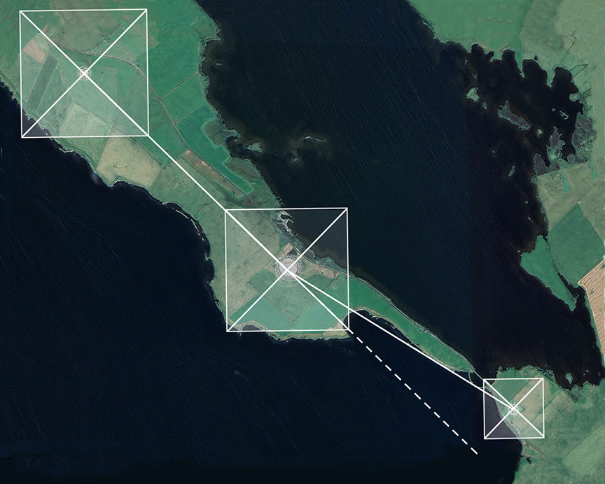
Orkney’s three stone circles with the Giza pyramids superimposed The Orkney archipelago has been called the Egypt of the North on account of the disproportionate number of Neolithic sacred sites – 3000 at last count – relative to its territory. The closest comparative example is Malta. Incidentally, a southward trajectory of 126 degrees through Brodgar and Stenness leads you directly to Giza. Across the archipelago, one finds something truly alien to the region: horned passage mounds. The northernmost is Point of Cott, now partially devoured by rising seas, its orthostatic box more at home in Sardinia than Britain, its alignment matching the first rising of Orion’s Belt on the winter solstice c.5300 BC. To the east lies Head of Work, its chamber marking the equinox sunrise c.5000 BC. And finally the heavily weathered horned mound at Vestra Fiold, not far from where the stone for the circles was quarried. The dates make them contemporaries of the stone circles. Marked on an OS map the three form a perfect isosceles triangle. I couldn’t help bisecting the angles to see what might lie at the center. The exact crossing point occurs on the island of Ramsay, at the base of a steep hill marked by Knowe of Lairo, a 130-foot long-horned mound. | Օրկնիի երեք քարե շրջանակները՝ Գիզայի բուրգերը վերադրված Օրկնեյի արշիպելագը կոչվել է Հյուսիսային Եգիպտոս՝ նեոլիթյան ժամանակաշրջանի սրբավայրերի անհամաչափ քանակի պատճառով՝ վերջին հաշվով 3000-ը՝ իր տարածքի համեմատ: Ամենամոտ համեմատական օրինակը Մալթան է։ Ի դեպ, Բրոդգարի և Ստենեսի միջով դեպի հարավ 126 աստիճանի հետագիծը ձեզ ուղիղ դեպի Գիզա է տանում: Արշիպելագի ամբողջ տարածքում կարելի է գտնել տարածաշրջանին իսկապես խորթ մի բան՝ եղջյուրավոր անցուղիներ: Ամենահյուսիսայինը Քոթի կետն է, որն այժմ մասամբ խժռված է բարձրացող ծովերով, նրա օրթոստատիկ տուփը ավելի շատ տանը Սարդինիայում է, քան Բրիտանիան, որի դասավորությունը համապատասխանում է Օրիոնի գոտու առաջին բարձրացմանը ձմեռային արևադարձին մ.թ.ա. մոտ 5300 թ. Արևելքում գտնվում է Աշխատանքի գլուխը, որի սենյակը նշում է արևածագի գիշերահավասարը մ.թ.ա. 5000 թ. Եվ վերջապես Վեստրա Ֆիոլդում գտնվող ուժեղ եղանակով քայքայված եղջյուրավոր բլուրը, այն վայրից ոչ հեռու, որտեղից հանվում էր շրջանակների քարը: Ժամկետները նրանց դարձնում են քարե շրջանների ժամանակակիցներ։ ՕՀ քարտեզի վրա նշված երեքը կազմում են կատարյալ հավասարաչափ եռանկյուն: Ես չէի կարող չկիսել անկյունները՝ տեսնելու, թե ինչ կարող է լինել կենտրոնում: Ճշգրիտ հատման կետը տեղի է ունենում Ռամսեյ կղզում, զառիթափ բլրի հիմքում, որը նշված է Նոու օ Լաիրոյի կողմից, 130 ոտնաչափ երկարությամբ երկար եղջյուրներով բլուր: |

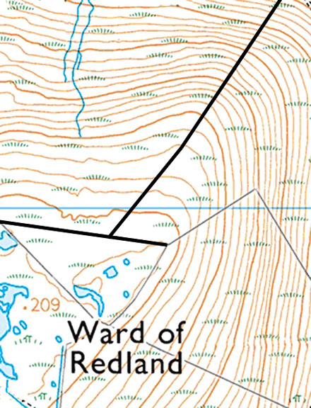
The original horned passage mound at Osono in Sardinia, and its later cousin on Orkney at Point of Cott. Both reference Orion. It is quite an effort to position four remote objects accurately using GPS alone, but to do so without technology across 340 square miles of undulating terrain, over waterways and hills is impressive. Here we have a kind of flattened pyramid outlined across Orkney, and what’s more, both the perimeter of the triangle and the trajectories of its bisecting lines are marked by a plethora of sites: chambered mounds, brochs, and summits of hills presumably used by an ancient surveyor. The north-south line, for example, ends on the summit of Ward of Redland, the highest point of a range of hills and from where one gets an unobstructed view of three of the four mounds. The exact spot of the construction line and its trajectory is still marked to this day by ancient field boundaries. | Բնօրինակ եղջյուրավոր անցուղի բլուրը Օսոնոյում, Սարդինիայում, և նրա ավելի ուշ զարմիկը Օրքնիում, Փոյնթ օֆ Քոթում: Երկուսն էլ հղում են Orion-ին: Չորս հեռավոր օբյեկտների ճշգրիտ տեղադրումը միայն GPS-ի միջոցով բավականին մեծ ջանքեր է, բայց դա անել առանց տեխնոլոգիայի 340 քառակուսի մղոն ալիքավոր տեղանքի, ջրային ուղիների և բլուրների վրայով տպավորիչ է: Այստեղ մենք ունենք մի տեսակ հարթեցված բուրգ, որը ուրվագծված է Օրքնիի վրայով, և ավելին, և՛ եռանկյունու պարագիծը, և՛ նրա բաժանվող գծերի հետագծերը նշվում են բազմաթիվ վայրերով. հնագույն չափագրող. Հյուսիս-հարավ գիծը, օրինակ, ավարտվում է Ռեդլենդի Ուարդլենդի գագաթին, բլուրների մի շարք ամենաբարձր կետը, որտեղից անխոչընդոտ տեսարան է բացվում չորս բլուրներից երեքի վրա: Շինարարական գծի ճշգրիտ տեղը և դրա հետագիծը մինչ օրս նշվում է հնագույն դաշտային սահմաններով: |
Modern field boundaries at the summit of Ward of Redland still mark the center trajectories of the Orkney triangle. Since the ancients were fond of mirroring things, it came as no surprise to find the Orkney triangle mirrored on the landscape, its southern tip touching the very edge of the island of Hoy, its construction lines marked by 18 known sites (despite a fair portion of the land now underwater), and just as Point of Cott marks the extreme north of the archipelago, so its mirrored opposite marks the southernmost. If ever there existed a horned mound here it is now submerged. | Ժամանակակից դաշտային սահմանները Ռեդլենդի Ուարդի գագաթին դեռևս նշում են Օրկնի եռանկյունու կենտրոնական հետագծերը: Քանի որ հին մարդիկ սիրում էին հայելային իրեր, զարմանալի չէր, որ Օրկնիի եռանկյունին հայտնվեց լանդշաֆտի վրա, որի հարավային ծայրը դիպչում էր Հոյ կղզու ծայրին, նրա շինարարական գծերը նշվում էին 18 հայտնի վայրերով (չնայած բավականին մեծ մասի): ցամաքի այժմ ստորջրյա), և ինչպես Քոթի կետը նշում է արշիպելագի ծայր հյուսիսը, այնպես էլ նրա հայելային հակառակ կողմը նշում է ամենահարավայինը: Եթե երբևէ եղել է եղջյուրավոր բլուր, այն այժմ ջրի տակ է: |

The Orkney Triangle and its mirror, with ground markers revealing its construction Orkney’s other oddity is the splendidly preserved Maeshowe, a passage mound predictably catalogued as a burial site despite the absence of human remains. Architecturally the inside of Maeshowe shares more in common with passage mounds of Mycenia and the kurgans of the Black Sea region than it does with Scotland. Kurgan derives from the Armenian kura-garq, ‘crucible of the social class’, and in the context of a circular building denotes a meeting place for high-ranking people – a select priesthood, if you like. The variant kura-grag (‘crucible of fire energy’) implies an astronomical connection and ties in nicely with Maeshowe’s alignment. However, anyone hoping to see the setting midwinter Sun reaching the rear niche will be three weeks too early to witness it, thanks to the effects of Precession. | Օրքնի եռանկյունին և նրա հայելին, որի կառուցումը բացահայտում է գետնի նշիչներով Օրքնիի մյուս տարօրինակությունը հիանալի պահպանված Մեյշոուն է, մի միջանցք, որը կանխատեսելիորեն գրանցված է որպես գերեզմանոց, չնայած մարդկային մնացորդների բացակայությանը: Ճարտարապետական առումով Մեյշոուի ներսը ավելի շատ ընդհանրություններ ունի Միկենիայի և Սև ծովի շրջանի կուրգանների հետ, քան Շոտլանդիայի հետ: Կուրգանը ծագում է հայկական քուրա-գարքից՝ «սոցիալական դասի խառնարան», և շրջանաձև շինության համատեքստում նշանակում է բարձրաստիճան մարդկանց հանդիպման վայր՝ ընտրյալ քահանայություն, եթե ցանկանում եք: Կուրա-գրագ տարբերակը («հրդեհային էներգիայի խառնարան») ենթադրում է աստղագիտական կապ և լավ կապված է Մեյշոուի դասավորության հետ: Այնուամենայնիվ, յուրաքանչյուր ոք, ով հուսով է տեսնել մայրամուտի արևը, որը հասնում է հետևի խորշին, երեք շաբաթ շատ շուտ կլինի դրա ականատեսը լինելու համար՝ շնորհիվ Precession-ի ազդեցության: |

Interior of Maeshowe during Farrer’s excavation 1862
Մեյշուի ինտերիերը Ֆարերի պեղումների ժամանակ 1862 թ
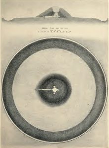
Plan and aerial view of Maeshowe and ring Crouching inside the passage of Maeshowe affords a selective view of a horizon formed by lowlands and the gap between the slopes of Ward Hill and Knap of Trowieglen on Hoy, essentially suggesting a bowl into which an object descends. Taking the earliest C-14 date of the mound at face value, it would have been 3990 BC when the midwinter Sun was seen descending into this bowl, followed by the Moon at its Minor Standstill, consecrating the cosmic marriage of masculine and feminine. But there’s more. On that same night Orion’s Belt is seen descending into the same bowl, a performance repeated once more on the spring equinox. The date implies Maeshowe was a later addition to the area, as proved by the discovery of an earlier stone platform with sockets for two massive stones, around which the mound was later erected. | Մեյշոուի և ռինգի պլան և օդային տեսք Մեյշոուի միջանցքի ներսում կռանալը հնարավորություն է տալիս ընտրովի տեսարան դեպի հորիզոն, որը ձևավորվել է հարթավայրերով և Ուորդ բլրի և Քնապի Տրովիգլենի լանջերի միջև ընկած բացը Հոյում, ըստ էության, առաջարկելով մի գունդ, որի մեջ իջնում է առարկան: Հաշվի առնելով բլուրի ամենավաղ C-14 ամսաթիվը, դա կլիներ մ.թ.ա. 3990 թվականը, երբ երևում էր, թե ինչպես է միջձմեռային Արևը իջնում այս ամանի մեջ, որին հաջորդում է Լուսինը՝ իր աննշան կանգառում՝ սրբացնելով արական և կանացի տիեզերական ամուսնությունը: Բայց կա ավելին: Նույն գիշերը Orion’s Belt-ը երևում է նույն ամանի մեջ իջնելիս, մի ներկայացում, որը ևս մեկ անգամ կրկնվել է գարնանային գիշերահավասարին: Ամսաթիվը ենթադրում է, որ Maeshowe-ն ավելի ուշ հավելումն է եղել տարածքին, ինչի մասին ապացուցվել է ավելի վաղ քարե հարթակի հայտնաբերմամբ՝ երկու հսկա քարերի համար վարդակներով, որոնց շուրջը հետագայում կառուցվել է թմբը: |
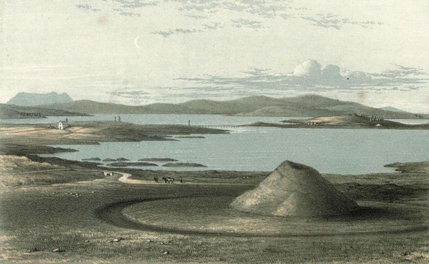
Maeshowe with Stenness and Brodgar in the distance, 1862
Մեյշոուն Սթեննեսի և Բրոդգարի հետ հեռվում, 1862 թ

View from Maeshowe’s passage of the natural bowl into which set the Sun, Moon and Orion’s Belt in 3990 BC The surprise here is that ancient people rarely if ever commemorated or celebrated the setting of objects in the sky, but rather their rising or mid-heaven positions when the energy of such ‘gods’ was deemed to be at its most abundant. Much in the same way, no one celebrates an empty glass of Scotch. This glitch at Maeshowe has been bugging me for years, leading me to speculate that the mound’s reference to the setting of celestial objects was important to people for whom this was culturally significant, and as far as I’m aware, the Egyptians and Armenians are the two rare cultures known to do so. In the Armenian language, Maeshowe appears as marz-hay (pronounced mez-hui), the ‘domain of Armenians’ or ‘domain of Orion’ (hay/hayk refers to both Orion and Armenians). Bringing the Armenian god Ara into the equation, where, depending on the context, the root ar means ‘assembly’, ‘nobility’, ‘power’ and ‘sun’, we can take the variant mes-ar to mean ‘assembly of nobility’ or ‘assembly of the sun’. Archaeological, genetic and archaeo-astronomical data suggest the ancient architects bypassed mainland Britain and arrived first in Orkney, then followed west towards the Outer Hebrides. Hebrides is a corruption of Hy Bridhe, ‘Isles of the Brides’, possibly in commemoration of the Gaelic goddess Bridhe. Another possibility rests on the movement of language, with Gaelic having evolved from Indo-European regions, specifically Asia Minor, with elements of Egyptian. With the Armenian language as the root, the word bryge was applied semantically to an elevated or illustrious class of people who originally migrated from the Armenian Highlands to western Europe; hy, on the other hand, is a contraction of hye, a person of Armenian origin, which itself derives from hayk, the Orion constellation. Thus to an Armenian visitor, Hye Bryges ostensibly means ‘domain of noble people of Orion’ or ‘domain of noble people of Armenian origin’. This may explain the Gaelic term for the Hebrides, Inse Gall, ‘islands of the strangers’, most likely given to a people arriving from afar of sufficiently contrasting physiognomy for it to be memorialized. Stone circles and standing stones are also a feature of the Outer Hebrides, the Isle of Lewis in particular. Just as Brodgar and Stenness are both located on major fault lines, so the impressive stone circle and cruciform stone rows of Callanish, along with its attendant sites, cluster within an extremely strong gravity anomaly zone, while the circles themselves delineate a localized region of low natural magnetism. It is therefore odd that amid such meticulous calculation, the ancient architects chose to place Callanish where a prominent crag by the name of Cnoc an Tursa blocks an otherwise uninterrupted view of the horizon. Looking at Callanish from afar, it becomes clear that the circle and its central monolith are deliberately using the mound-shaped crag, least of all because sockets for the missing stones are located there, along with a large back-filled socket for a stone whose scale would have created a focal point in itself. | Տեսարան Մեյշոուի անցումից բնական ամանի մեջ, որի մեջ մտան Արևը, Լուսինը և Օրիոնի գոտին մ.թ.ա. 3990 թ. Այստեղ զարմանքն այն է, որ հնագույն մարդիկ հազվադեպ են հիշատակել կամ նշել երկնքում առարկաների տեղադրումը, այլ ավելի շուտ նրանց վերելքի կամ երկնքի միջին դիրքերը, երբ համարվում էր, որ նման «աստվածների» էներգիան ամենաշատն է: Նույն կերպ ոչ ոք չի տոնում շոտլանդական դատարկ բաժակը: Maeshowe-ի այս անսարքությունը տարիներ շարունակ անհանգստացնում էր ինձ, և ինձ ստիպեց ենթադրել, որ բլուրի հղումը երկնային օբյեկտների տեղակայմանը կարևոր է այն մարդկանց համար, ում համար դա կարևոր է մշակութային առումով, և որքանով ես տեղյակ եմ, եգիպտացիներն ու հայերը երկու հազվագյուտ մշակույթները, որոնք հայտնի են դրանով: Հայերենում Մեյշոուն հանդես է գալիս որպես մարզ-հայ (արտասանվում է մեզ-հույ), «հայերի տիրույթ» կամ «Օրիոնի տիրույթ» (հայ/հայկը վերաբերում է և՛ Օրիոնին, և՛ հայերին): Հայոց Արա աստծուն բերելով այն հավասարման, որտեղ, կախված համատեքստից, ար արմատը նշանակում է «ժողովուրդ», «ազնվականություն», «զորություն» և «արև», մենք կարող ենք «մես-ար» տարբերակն ընդունել որպես «ազնվականության ժողով»: կամ «արևի ժողով»։ Հնագիտական, գենետիկական և հնաստղագիտական տվյալները վկայում են այն մասին, որ հնագույն ճարտարապետները շրջանցել են մայրցամաքային Բրիտանիան և ժամանել նախ Օրքնի, այնուհետև հետևել արևմուտք՝ դեպի Արտաքին Հեբրիդներ: Հեբրիդները Հի Բրիդհի, «Հարսնացուների կղզիների» կոռուպցիան է, հնարավոր է՝ ի հիշատակ Գելիայի աստվածուհի Բրիդեի: Մեկ այլ հնարավորությունը հիմնված է լեզվի շարժման վրա, քանի որ գաելականը առաջացել է հնդեվրոպական շրջաններից, մասնավորապես՝ Փոքր Ասիայից՝ եգիպտերենի տարրերով: Արմատ ունենալով հայերենը, բրիգե բառը իմաստային իմաստով կիրառվել է Հայկական լեռնաշխարհից Արևմտյան Եվրոպա գաղթած մարդկանց բարձրակարգ կամ հռչակավոր դասի նկատմամբ. hy-ն, մյուս կողմից, հայի, հայկական ծագում ունեցող մարդու կծկում է, որն ինքնին բխում է Հայքից՝ Օրիոն համաստեղությունից։ Այսպիսով, Հայ Բրայգեսը հայ այցելուի համար իբր նշանակում է «Օրիոնի ազնվականների տիրույթ» կամ «հայկական ծագումով ազնվական մարդկանց տիրույթ»։ Սա կարող է բացատրել Հեբրիդների գաելական տերմինը՝ Ինսե Գալը, «օտարների կղզիները», որը, ամենայն հավանականությամբ, տրված է այն ժողովրդին, որը գալիս է հեռվից բավական հակապատկեր ֆիզիոգոմիայով, որպեսզի այն հիշատակվի։ Քարե շրջանակները և կանգուն քարերը նույնպես արտաքին Հեբրիդների, մասնավորապես Լյուիս կղզու հատկանիշն են: Ճիշտ այնպես, ինչպես Բրոդգարն ու Ստեննեսը երկուսն էլ գտնվում են հիմնական խզվածքի գծերի վրա, այնպես էլ Քալանիշի տպավորիչ քարե շրջանը և խաչաձև քարե շարքերը, իր ուղեկցող տեղամասերի հետ միասին, հավաքվում են չափազանց ուժեղ ձգողականության անոմալիա գոտում, մինչդեռ շրջանակներն իրենք ուրվագծում են ցածր տեղայնացված շրջանը: բնական մագնիսականություն. Հետևաբար տարօրինակ է, որ նման մանրակրկիտ հաշվարկների ժամանակ հնագույն ճարտարապետները որոշեցին տեղադրել Callanish-ը այնտեղ, որտեղ Cnoc an Tursa անունով նշանավոր ժայռը փակում է հորիզոնի անխափան տեսարանը: Հեռվից նայելով Կալանիշին, պարզ է դառնում, որ շրջանը և նրա կենտրոնական մոնոլիտը միտումնավոր օգտագործում են թմբի ձևավորված ժայռը, ամենաքիչը այն պատճառով, որ այնտեղ տեղադրված են բացակայող քարերի վարդակներ, ինչպես նաև մի մեծ վարդակ՝ քարի համար: մասշտաբը ինքնին կիզակետ կստեղծեր: |
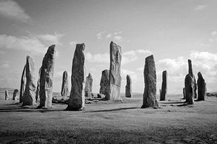
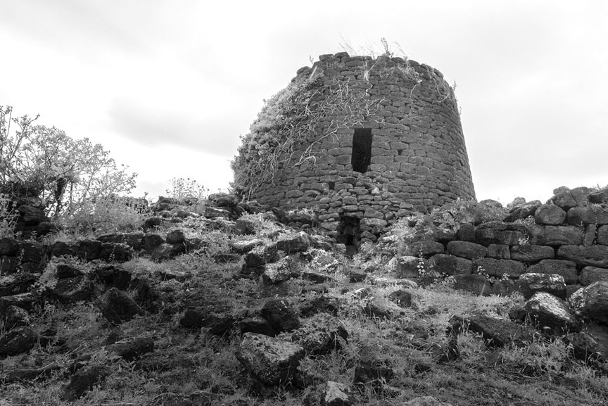
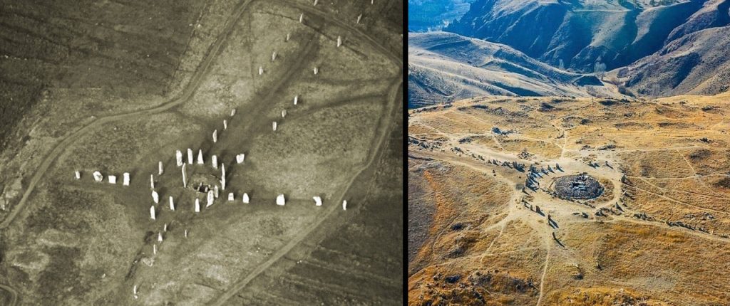
Callanish central ring, with Cloch an Tursa on the far right I recalled the stone circles of Orkney and how they mirror the first rising of Orion’s Belt on the winter solstice c.5300 BC. No such association has ever been explored at Callanish, but if made it would establish a coherent pattern of behaviour by the elusive architects. Standing inside the circle looking down the southerly row of stones towards Cnoc an Tursa, Orion’s Belt rose for the first time above the crag on the winter solstice c.5000 BC. At the same moment, looking back at the opposite end of the avenue, which aligns to the celestial pole, the bright star Vega appeared above the stones. This dual relationship presents itself at another striking ancient monument 2500 miles away in the region that used to be ancient Armenia – the enigmatic Stone Circle D at Gobekli Tepe – the difference being that it took place there five-and-a-half thousand years earlier. As I published in my previous book The Missing Lands, the original site was located in Armenian territory and called Port-asar, literally ‘umbilical cord of Osiris’, who is the earthly counterpart of Orion. Be that as it may, the most unusual monument on Lewis is neither a megalith nor a stone circle. A few miles north of Callanish stands a tapered stone tower, Dun Carloway. Like others of its kind, it has vexed historians because these iconic structures are unique to Orkney, Shetland, the Western Isles and the tip of northern Scotland. To quote one: “It means that we have here the remains of a period of architectural activity which has no parallel in the early history of our country.” Dun Carloway has been used, reused and adapted over time. It is built of well-fitted stone without mortar. The central courtyard is surrounded by a hollow wall, inside which a staircase winds its way to where there used to be upper galleries; windows appear to have been sparse. The tower incorporates features far and beyond what is necessary in a residence, for example, the design is based on music ratios: its external to internal diameter conforms to the octave; the main door is framed to a ratio of 1.33:1, equivalent to the note F; the wall from north to south varies in thickness by Pi. It’s as though the residence was intended for a musician or a mathematician. Or an observer of the sky perhaps? The entrance is impractically placed to face the most windswept direction off the ocean but faces a pointed rock ledge that references the Minor Lunar Standstill as well as the Crossquarters – the midpoints between solstices and equinoxes that mark the beginning of seasons in the Celtic calendar. All this specialist information seems far beyond the everyday requirements of eating and sleeping. There is evidence of people living here in 100 BC but if the tower was meant to offer long-term protection from raiders (the other explanation), the fact that it could shelter no more than a dozen people and animals comfortably, and had no access to a well or sewage disposal, means that two weeks of siege was all the effort required before the besieged began to look at urine as fine wine or to each other as a source of nourishment. There is also the problem of the tower standing fifty feet lower than the adjacent bedrock. As any military strategist knows, if you don’t own the high ground the outcome will not be positive. Perhaps the tower, like the ancient monuments around it, was inherited from an earlier period and re-used by different people with different needs? Put through Armenian etymology Dun Carloway is best broken down as: dun(dwelling) or dohm (a noble race or family); and kar (stone), ogh (ring or circle), e’ag (being, existence), forming Dun Kar-ogh-e’ag, ‘existence of the circular stone dwelling of a family of noble race.’ A trip to the Mediterranean island of Sardinia reveals 6500 towers resembling Dun Carloway, each with traditions associating them with seafaring astronomers, very tall ones at that, who migrated here over 8000 years ago from the Armenian Highlands, leaving a genetic footprint in the present population. Such nuraghe lent their name to an entire civilization and yet no one can satisfactorily explain where this word came from or what it means. Many nuraghe can comfortably house no more than four people and have no access to water, making them useless as fortifications; certainly, they were not cost-effective. However, their low entrances, dark interiors, and narrow windows focussed on the artificially flattened summits of nearby hills are all indicative of observatories. Indeed, one observation at nuraghe Ruju and Santu Antine allowed me to calculate the first to mark the rising of Orion and Sirius out of the summit on the winter solstice in 6000 BC, then watching their trajectories descend into the next flattened summit, as observed from the window in nuraghe Santu Antine. | Կալանիշի կենտրոնական օղակը, աջ կողմում գտնվող Կլոչ ան Տուրսա Ես հիշեցի Օրկնեյի քարե շրջանակները և ինչպես են դրանք արտացոլում Օրիոնի գոտու առաջին վերելքը ձմեռային արևադարձին մոտ 5300 մ.թ.ա. Նման ասոցիացիան երբևէ չի ուսումնասիրվել Callanish-ում, բայց եթե այն ստեղծվի, այն կստեղծի խուսափողական ճարտարապետների վարքագծի համահունչ օրինակ: Շրջանակի ներսում կանգնած՝ նայելով քարերի հարավային շարքը դեպի Cnoc an Tursa, Օրիոնի գոտին առաջին անգամ բարձրացավ ժայռից վեր՝ մ.թ.ա. մոտ 5000 թ. ձմեռային արևադարձին: Նույն պահին, ետ նայելով պողոտայի հակառակ ծայրին, որը հարթվում է երկնային բևեռին, քարերի վերևում հայտնվեց վառ աստղ Վեգան։ Այս երկակի հարաբերությունը հայտնվում է մեկ այլ տպավորիչ հնագույն հուշարձանում, որը գտնվում էր 2500 մղոն հեռավորության վրա, այն տարածաշրջանում, որը նախկինում եղել է Հին Հայաստանը. . Ինչպես ես հրապարակել էի իմ նախորդ «Անհետացած հողերը» գրքում, սկզբնական կայքը գտնվում էր հայկական տարածքում և կոչվում էր Պորտ-ասար, բառացիորեն «Օսիրիսի պորտալար», որը Օրիոնի երկրային նմանակն է: Ինչևէ, Լյուիսի ամենաանսովոր հուշարձանը ոչ մեգալիթ է, ոչ էլ քարե շրջան: Կալանիշից մի քանի մղոն դեպի հյուսիս կանգնած է Դան Քարլոուեյը, որն ունի կոնաձև քարե աշտարակ: Իր տեսակի մեջ մյուսների նման, այն զայրացրել է պատմաբաններին, քանի որ այս խորհրդանշական կառույցները եզակի են Օրքնիի, Շեթլանդի, Արևմտյան կղզիների և հյուսիսային Շոտլանդիայի ծայրամասերի համար: Մեջբերեմ մեկը. «Դա նշանակում է, որ մենք այստեղ ունենք ճարտարապետական գործունեության մի շրջանի մնացորդներ, որոնք նմանը չունեն մեր երկրի վաղ պատմության մեջ»: Dun Carloway-ը ժամանակի ընթացքում օգտագործվել, վերաօգտագործվել և հարմարեցվել է: Շինված է հարմարեցված քարով՝ առանց շաղախի։ Կենտրոնական բակը շրջապատված է սնամեջ պարսպով, որի ներսում սանդուղք ոլորվում է դեպի այնտեղ, որտեղ նախկինում վերին պատկերասրահներ են եղել. պատուհանները կարծես նոսր են եղել: Աշտարակը ներառում է առանձնահատուկ առանձնահատկություններ, որոնք շատ ավելին են, ինչ անհրաժեշտ է բնակության համար, օրինակ, դիզայնը հիմնված է երաժշտության հարաբերակցության վրա. արտաքին և ներքին տրամագիծը համապատասխանում է օկտավային; հիմնական դուռը շրջանակված է 1,33:1 հարաբերակցությամբ, որը համարժեք է F նշումին; հյուսիսից հարավ պատի հաստությունը տատանվում է Pi-ով: Կարծես նստավայրը նախատեսված էր երաժշտի կամ մաթեմատիկոսի համար։ Կամ գուցե երկնքի դիտորդը: Մուտքը գործնականում տեղադրված է օվկիանոսից ամենաշատ քամուց քշված ուղղությամբ, բայց կանգնած է սրածայր ժայռի եզրին, որը վկայակոչում է Փոքր լուսնային կանգառը, ինչպես նաև խաչմերուկը՝ արևադարձների և գիշերահավասարների միջնակետերը, որոնք նշում են սեզոնների սկիզբը կելտական օրացույցում: Մասնագետների այս ամբողջ տեղեկատվությունը շատ ավելին է, քան ուտելու և քնելու ամենօրյա պահանջները: Կան վկայություններ այն մասին, որ մարդիկ ապրում էին այստեղ մ.թ.ա. 100 թվականին, բայց եթե աշտարակը նախատեսված էր երկարաժամկետ պաշտպանություն արշավորդներից (մյուս բացատրությունը), այն փաստը, որ այն կարող էր հարմարավետորեն պատսպարել ոչ ավելի, քան մեկ տասնյակ մարդ և կենդանի, և մուտք չուներ։ ջրհորի կամ կեղտաջրերի հեռացման համար, նշանակում է, որ երկու շաբաթվա պաշարումը ամբողջ ջանքերն էին, որոնք պահանջվում էին, նախքան պաշարվածները սկսեցին մեզը դիտել որպես նուրբ գինի կամ միմյանց՝ որպես սնուցման աղբյուր: Կա նաև աշտարակի խնդիրը հարակից հիմնաքարից հիսուն ոտնաչափ ցածր: Ինչպես գիտի ցանկացած ռազմական ստրատեգ, եթե չտիրապետես բարձր դիրքին, արդյունքը դրական չի լինի: Միգուցե աշտարակը, ինչպես իր շուրջը գտնվող հնագույն հուշարձանները, ժառանգվել է ավելի վաղ ժամանակաշրջանից և նորից օգտագործվել տարբեր կարիքներ ունեցող մարդկանց կողմից: Հայկական ստուգաբանությամբ Դուն Քարլոուեյը լավագույնս բաժանվում է հետևյալ կերպ. and kar (քար), օղ (մատանի կամ շրջան), e’ag (գոյություն, գոյություն), ձևավորելով Dun Kar-ogh-e’ag, «ազնվական ռասայի ընտանիքի շրջանաձև քարե բնակարանի գոյությունը»։ Միջերկրական ծովի Սարդինիա կղզի կատարած ուղևորությունը բացահայտում է 6500 աշտարակ, որոնք նման են Դուն Կարլոուեյին, որոնցից յուրաքանչյուրն ունի ավանդույթներ, որոնք դրանք կապում են ծովագնաց աստղագետների հետ, ընդ որում՝ շատ բարձրահասակ, ովքեր այստեղ են գաղթել ավելի քան 8000 տարի առաջ Հայկական լեռնաշխարհից՝ թողնելով գենետիկ հետք ներկայիս բնակչության մեջ: . Այսպիսի նուրագեները իրենց անունը տվել են մի ամբողջ քաղաքակրթության, սակայն ոչ ոք չի կարող գոհացուցիչ բացատրել, թե որտեղից է առաջացել այս բառը կամ ինչ է այն նշանակում: Շատ նուրաղներ կարող են հարմարավետորեն տեղավորել ոչ ավելի, քան չորս հոգի և չունեն ջրի հասանելիություն, ինչը նրանց դարձնում է անպիտան որպես ամրություններ. իհարկե, դրանք ծախսարդյունավետ չէին: Այնուամենայնիվ, նրանց ցածր մուտքերը, մուգ ինտերիերը և նեղ պատուհանները, որոնք կենտրոնացած են մոտակա բլուրների արհեստականորեն հարթեցված գագաթների վրա, բոլորը վկայում են աստղադիտարանների մասին: Իրոք, մի դիտարկում Նուրագե Ռուջուում և Սանտու Անտինում թույլ տվեց ինձ հաշվարկել առաջինը, որը նշանավորեց Օրիոնի և Սիրիուսի բարձրանալը ձմեռային արևադարձի գագաթից մ.թ.ա. 6000 թ. պատուհանը նուրագե Սանտու Անտինեում: |

Dun Carloway. And nuraghe Ruju in Sardinia, where 6500 similar towers predate those of Scotland
Դան Քարլոուեյ. Եվ նուրագե Ռուջուն Սարդինիայում, որտեղ 6500 նմանատիպ աշտարակները նախորդում են Շոտլանդիայի աշտարակներին
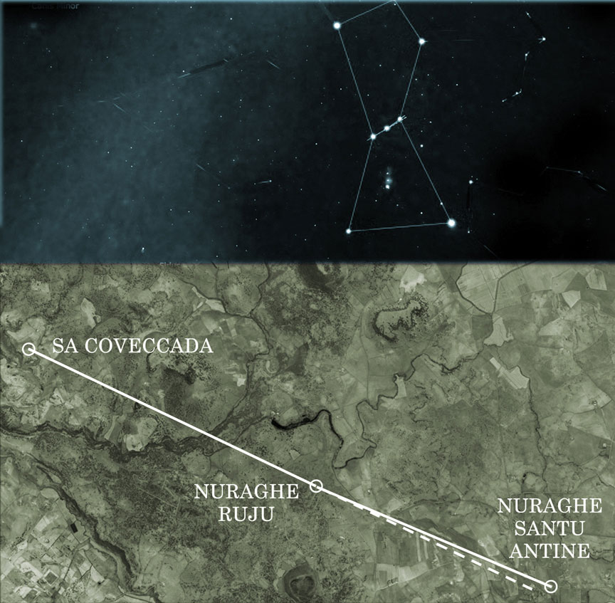
| And just as Bookan is the odd one out in Orkney, so in Sardinia the Ruju-Santu Antine alignment is completed by the passage mound Sa Coveccada, forming a near-straight line, with the third site offset by 2 degrees, altogether mirroring the belt stars of Orion — as they appeared above this location at mid-heaven in the era of 6000 BC. | Եվ ինչպես Բուկանը տարօրինակն է Օրկնիում, այնպես էլ Սարդինիայում Ռուջու-Սանտու Անտինե հարթեցումն ավարտվում է Սա Կովեկադա լեռնանցքով, կազմելով գրեթե ուղիղ գիծ, երրորդ տեղանքը 2 աստիճանով շեղված է, ամբողջությամբ արտացոլելով գոտին: Օրիոնի աստղերը, երբ նրանք հայտնվեցին այս վայրի վերևում՝ երկնքի կեսին, մ.թ.ա. 6000 թ. |
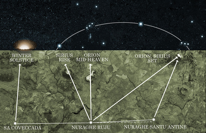
Sunrise, and trajectories of Orion and Sirius as observed from windows in nuraghe Ruju and Santu Antine, and Sa Coveccada. 6000 BC
Արևածագը և Օրիոնի և Սիրիուսի հետագծերը, ինչպես դիտվում են նուրագե Ռուջու և Սանտու Անտինե և Սա Կովեկադայի պատուհաններից: 6000 մ.թ.ա
The mirroring of Orion’s Belt in Sardinia Sardinia is also home to horned mounds, possibly the oldest in existence. They are classified as tomba di giganti except no giants’ remains have been found inside the orthostatic boxes that once were covered with soil, just like the Orkney mounds. Instead, the remains of very, very tall people have been found all over the island in common graves. A cursory investigation into the alignment of these horned mounds indeed finds them all predating those on Orkney by as much as 2500 years, with many marking the rising of Orion on the winter solstice from 4000-5200 BC, with the site at Iloi marking its mid-heaven position in 7200 BC, and Li Loighi and Imbertighe establishing the oldest correspondence, on the equinox of 8500 BC. Now it gets interesting. As language and people moved westwards from Armenia into the Mediterranean, towards the islands of Malta and Sardinia, the Maltese word nur is traced to Azerbaijan (what used to be old Armenia), its aggregate meaning being ‘just or rightful, light or shining person’. Classical Armenian offers specific details about these rightful people. The word nuirag refers to a ‘holy representative or legate’, from which derives nuyral (devoted). Altogether, the nuraghe of Sardinia are best described as places of ‘the rightful, white, shining, holy representatives’. Incidentally, the Armenian solar god Ardi was wedded to the goddess Sel-ardi, and as the name migrated it took on the shorthand form S’ardi, as in ‘belonging to Ardi’, from which developed Sardinia, ‘the land of the bride of the Sun’. This overlap of values between ancient Armenian culture and Sardinia, along with people clearly attached to Orion, led me to examine the origin of Scotland’s sacred place names. Orkney is best defined as ar-kar-negh (narrow stones of the god), a possible reference to the visual characteristics of Stenness. This seat of council comes up as tses-nisd (place of ritual) and s’tenel-nish (to place a mark). But Egyptian etymology is even closer to the mark: s-ten-nes (to arrive at a distinguished place), and seh-t-en-nes (to approach the place of council). Perched on high ground, the Ring of Bookan or Bukan forms the tail of a string of circles. In Armenian, poch’-gahmeans ‘tail stones’ (bear in mind that certain vowels and consonants are interchangeable due to linguistic and geographic variants over time). The Ring of Brodgar, or Broggar, is described in local folklore as a place where giants danced to music and were turned to stone. Its Armenian equivalent barerq-kar means ‘dance song stones’. However, there is an even closer Egyptian root: b-ra-gah, ‘abode or shrine of the Sun god’. Turning to the stone circles of Lewis we find Ceann Hulavig’s original Gaelic name Sron A’Chail to originate from the Armenian srah achk-aha, ‘the room of seeing’. The summit of Callanish is marked by the outcrop Cloch an Tursa, and tur-sar literally means ‘door or gateway to the summit’. As for Callanish, it was so good they named it twice. The first Armenian interpretation remains almost intact: kar-nish (a stone marker), along with the variants kharag-nish (rock cliff marker), and khachanish (to mark or cross). The site’s Gaelic name Tursachan is explicitly referenced as tur-sa-quah (doorway to the stone seat or throne), although a visiting Egyptian might expand on this with Ta Ur S-aqer, ‘to make perfect the great land of the gods’. | Հայկի Գոտու հայելին Սարդինիայում Սարդինիայում են գտնվում նաև եղջյուրավոր թմբերը, որոնք, հնարավոր է, գոյություն ունեցող ամենահինն են։ Դրանք դասակարգվում են որպես tomba di giganti, բացառությամբ, որ հսկաների մնացորդներ չեն հայտնաբերվել օրթոստատիկ արկղերի ներսում, որոնք ժամանակին ծածկված էին հողով, ինչպես Օրկնիի բլուրները: Փոխարենը, շատ, շատ բարձրահասակ մարդկանց մնացորդները հայտնաբերվել են ամբողջ կղզում ընդհանուր գերեզմաններում: Այս եղջյուրավոր բլուրների դասավորվածության հպանցիկ ուսումնասիրությունը, իրոք, գտնում է, որ դրանք բոլորն էլ ավելի վաղ են եղել Օրքնիում 2500 տարով, որոնցից շատերը նշում են Օրիոնի վերելքը ձմեռային արևադարձի ժամանակ մ. - դրախտի դիրքը մ.թ.ա. 7200 թվականին, և Լի Լոյգին և Իմբերտիգեն հաստատել են ամենահին նամակագրությունը՝ մ.թ.ա. 8500 թվականի գիշերահավասարին: Հիմա հետաքրքիր է դառնում։ Երբ լեզուն և մարդիկ Հայաստանից դեպի արևմուտք շարժվեցին դեպի Միջերկրական ծով՝ դեպի Մալթա և Սարդինիա կղզիներ, մալթերեն nur բառը հետագծվել է Ադրբեջանում (նախկինում հին Հայաստանն էր), որի ընդհանուր իմաստը «արդար կամ իրավացի, թեթև կամ փայլուն մարդ» է։ '. Դասական հայերենը կոնկրետ մանրամասներ է առաջարկում այս իրավացի մարդկանց մասին։ Նուիրագ բառը վերաբերում է «սուրբ ներկայացուցիչին կամ լեգատին», որից ծագում է նույրալ (նվիրված): Ընդհանուր առմամբ, Սարդինիայի նուրագեն լավագույնս բնութագրվում է որպես «իրավական, սպիտակ, փայլուն, սուրբ ներկայացուցիչների» վայրեր: Ի դեպ, հայկական արևի աստված Արդին ամուսնացել է Սել-արդի աստվածուհու հետ, և երբ անունը գաղթել է, ստացել է S'ardi սղագրության ձևը, ինչպես «Արդիին պատկանելը», որտեղից զարգացել է Սարդինիան՝ «հարսի երկիրը»: արևի։ Հին հայկական մշակույթի և Սարդինիայի արժեքների այս համընկնումը, Օրիոնին հստակորեն կապված մարդկանց հետ միասին, ստիպեցին ինձ ուսումնասիրել Շոտլանդիայի սուրբ տեղանունների ծագումը: Օրքնին լավագույնս սահմանվում է որպես ար-կար-նեղ (աստծո նեղ քարեր), որը հնարավոր հղում է Ստեննեսի տեսողական բնութագրերին: Խորհրդի այս նստավայրը առաջանում է որպես ցես-նիսդ (ծիսակատարության վայր) և ստենել-նիշ (նշան դնելու համար): Բայց եգիպտական ստուգաբանությունն էլ ավելի մոտ է նշագծին՝ s-ten-nes (հասնել նշանավոր վայր) և seh-t-en-nes (խորհրդի վայրին մոտենալ): Բուկանի կամ Բուկանի Մատանին, որը տեղադրված է բարձր գետնի վրա, կազմում է շրջանակների շարանի պոչը: Հայերենում «պոչ»-գահը նշանակում է «պոչի քարեր» (նկատի ունեցեք, որ որոշ ձայնավորներ և բաղաձայններ ժամանակի ընթացքում լեզվական և աշխարհագրական տարբերակների պատճառով փոխարինելի են): Բրոդգարի մատանին կամ Բրոգգարը տեղական բանահյուսության մեջ նկարագրվում է որպես մի վայր, որտեղ հսկաները պարում էին երաժշտության ներքո և վերածվում քարի։ Դրա հայերեն համարժեքը բարերք-կար նշանակում է «պարերգի քարեր»։ Այնուամենայնիվ, կա ավելի մոտ եգիպտական արմատ. b-ra-gah, «Արևի աստծո բնակավայրը կամ սրբավայրը»: Անդրադառնալով Լյուիսի քարե շրջանակներին՝ մենք գտնում ենք, որ Ceann Hulavig-ի բնօրինակ գաելական անունը Sron A’Chail ծագել է հայերեն srah achk-aha՝ «տեսնելու սենյակ» բառից: Կալանիշի գագաթը նշանավորվում է Կլոչ ան Տուրսա գագաթով, և tur-sar բառացիորեն նշանակում է «գագաթի դուռ կամ դարպաս»: Ինչ վերաբերում է Քալանիշին, այն այնքան լավ էր, որ երկու անգամ անվանեցին: Գրեթե անփոփոխ է մնում հայերեն առաջին մեկնությունը՝ կար-նիշ (քար նշիչ), խարագ-նիշ (ժայռափոր նշիչ) և խաչանիշ (նշել կամ խաչել) տարբերակների հետ միասին։ Կայքի գալիկական անունը՝ Tursachan բացահայտորեն նշվում է որպես tur-sa-quah (դուռ դեպի քարե աթոռ կամ գահ), չնայած այցելող եգիպտացին կարող է դա ընդարձակել Ta Ur S-aqer-ով, «աստվածների մեծ երկիրը կատարյալ դարձնելու համար»: . |

Callanish 1859, still partially buried in peat
Քալանիշ 1859, դեռ մասամբ թաղված տորֆի մեջ
Callanish and its earlier Armenian sibling, Karahunj But who might these gods have been? The only surviving reference to the ancient architects are their names: Papae and Peti. The Peti of Orkney were considered to have been the original settlers, described as “people of strange habits” who spoke a different language. Both Peti and Papae were associated with abodes of a sacred nature and wore long white robes, the kind of garment typically identifying a priest or sage in ancient temple tradition. Perhaps one group mapped the sky while the other attended to stonemasonry and monuments, anchoring the calculations to the land. Such a division of roles was common in the temple raising practices of ancient Egypt, and an examination of these people’s etymological fingerprint reveals a definite intertwinement. Access to the Egyptian temple was restricted to the learned, the purified and the initiated, qualities reflected in their white robes of office, and the title petriu, ‘those who see’ — visionaries, initiates with more finely attuned faculties, precisely the kind of responsible individuals one wants in charge of a sacred environment. The related term petiu is even closer to the Scottish name. It means ‘heavenly beings’, while the derivative petr means ‘a region of sky’, so clearly the petriu or petiu, and by extension, the Peti, were involved with understanding the stars. They were referred to in Persia (the region known earlier as Sumeria, whose cultural stratum overlays earlier migrants from Armenia) as peri, whom they described as elegant and puissant, tall and graceful people possessing the gifts of clairvoyance and the ability to walk between worlds. The name followed them to Ireland where it was modified to Feadh-Ree (faery, the fair people) to reflect the local dialect. The name Papae, on the other hand, comes from the Armenian p’apegh, a monk or holy person. Its diminutive papdenotes ‘a grandfather or elder’, while the extension papenakan means ‘inherited from ancestors’. If the picture painted here is correct — and I am paraphrasing an entire book — then we are presented in Orkney, the Hebrides, and Ireland too, with a priestly class possessing an ancient inherited knowledge handed down from an established yet remote culture, and as early British chroniclers correctly noted, they were not local. As from where these strangers might have originated, on the basis of modern population samples, one genetic group migrated from Scythia to eastern Scotland, while Y-chromosomal evidence suggests a second group migrated up to 3000 BC from the Mediterranean and Iberia to the western and southern British Isles, contributing 24% of modern genetic lines. But perhaps the most telling study concerns the DNA of Scotland’s highly diverse people, which pinpoints their origins in Siberia, Arabia and Egypt. | Քալանիշը և նրա նախկին հայ եղբայրը՝ Քարահունջը Բայց ովքե՞ր կարող էին լինել այս աստվածները: Հին ճարտարապետների մասին պահպանված միակ հիշատակումը նրանց անուններն են՝ Պապա և Պետի: Համարվում էր, որ Օրքնեի Պետիները եղել են սկզբնական վերաբնակիչները, որոնք նկարագրված են որպես «տարօրինակ սովորությունների մարդիկ», ովքեր խոսում էին այլ լեզվով։ Ե՛վ Պետին, և՛ Պապեն կապված էին սուրբ բնության կացարանների հետ և կրում էին երկար սպիտակ զգեստներ, հագուստի տեսակ, որը սովորաբար նույնացնում էր քահանան կամ իմաստունը հին տաճարային ավանդույթներում: Հավանաբար մի խումբը քարտեզագրել է երկինքը, իսկ մյուսը զբաղվել է քարաշենության և հուշարձանների վրա՝ հաշվարկները խարսխելով հողի վրա: Դերերի նման բաժանումը սովորական էր Հին Եգիպտոսի տաճարների բարձրացման պրակտիկայում, և այս մարդկանց ստուգաբանական մատնահետքի ուսումնասիրությունը բացահայտում է որոշակի փոխկապակցվածություն: Եգիպտական տաճար մուտք գործելը սահմանափակված էր գիտուն, մաքրված և նախաձեռնված որակներով, որոնք արտացոլված էին նրանց պաշտոնի սպիտակ զգեստների մեջ, իսկ Պետրիու տիտղոսը, «նրանք, ովքեր տեսնում են»՝ տեսիլքներ, նախաձեռնողներ՝ ավելի լավ ներդաշնակված կարողություններով, հենց այն տեսակի պատասխանատու անհատներ, ովքեր ցանկանում են, որ պատասխանատու լինեն սուրբ միջավայրի համար: Կապված «petiu» տերմինն ավելի մոտ է շոտլանդական անվանը: Դա նշանակում է «երկնային էակներ», մինչդեռ petr ածանցյալը նշանակում է «երկնքի շրջան», ուստի ակնհայտորեն petriu-ն կամ petiu-ն և ըստ ընդարձակման՝ Peti-ն ներգրավված էին աստղերի ըմբռնման հետ: Պարսկաստանում (տարածաշրջանը, որը ավելի վաղ հայտնի էր որպես Շումերիա, որի մշակութային շերտը ընդգրկում է ավելի վաղ Հայաստանից գաղթականներին) անվանում էին peri, որոնց նրանք նկարագրում էին որպես նրբագեղ և եռանդուն, բարձրահասակ և նրբագեղ մարդիկ, ովքեր օժտված էին պայծառատեսության և աշխարհների միջև քայլելու կարողությամբ։ . Անունը նրանց հետևեց մինչև Իռլանդիա, որտեղ այն փոխվեց Ֆեադ-Ռիի (փերի, գեղեցիկ մարդիկ)՝ տեղական բարբառը արտացոլելու համար: Պապաե անունը, ընդհակառակը, առաջացել է հայկական փափեղ՝ վանական կամ սուրբ անձնավորությունից։ Նրա փոքրածավալ պապը նշանակում է «պապ կամ երեց», մինչդեռ papenakan ընդլայնումը նշանակում է «նախահայրերից ժառանգված»: Եթե այստեղ նկարված նկարը ճիշտ է, և ես վերափոխում եմ մի ամբողջ գիրք, ապա մենք նույնպես ներկայացված ենք Օրկնիում, Հեբրիդներում և Իռլանդիայում՝ քահանայական դասի հետ, որը տիրապետում է հնագույն ժառանգական գիտելիքներին, որոնք փոխանցվել են կայացած, բայց հեռավոր մշակույթից, և ինչպես Բրիտանացի վաղ շրջանի մատենագիրները ճիշտ նշել են, որ նրանք տեղացի չեն եղել: Ինչ վերաբերում է նրան, թե որտեղից կարող էին ծագել այս անծանոթները, ժամանակակից բնակչության նմուշների հիման վրա մեկ գենետիկ խումբ գաղթել է Սկյութիայից Արևելյան Շոտլանդիա, մինչդեռ Y-քրոմոսոմային ապացույցները ցույց են տալիս, որ երկրորդ խումբը գաղթել է մինչև մ.թ.ա. 3000 թվականը Միջերկրական ծովից և Իբերիայից դեպի արևմուտք և հարավային Բրիտանական կղզիները, որոնք նպաստում են ժամանակակից գենետիկական գծերի 24%-ին: Սակայն, թերևս, ամենահայտնի ուսումնասիրությունը վերաբերում է Շոտլանդիայի շատ բազմազան մարդկանց ԴՆԹ-ին, որը հստակ ցույց է տալիս նրանց ծագումը Սիբիրում, Արաբիայում և Եգիպտոսում: |
Source: Freddy Silva, Scotland’s Hidden Sacred Past, published December 2021. Author website by invisibletemple.com